
Having recently used this old Victorian map of Scotland to mark all the ruins I’ve visited since this project began, I thought now would be a good opportunity to share my enthusiasm for the art of map-making.
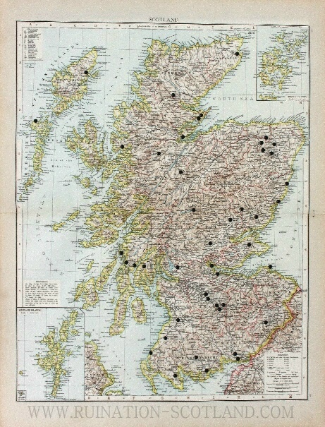
Much as I appreciate online mapping programs and the value of a trusty Sat Nav, without which I would sometimes be quite literally lost, I still adore paper maps. I always plot my ruin-hunting expeditions on paper, but this is actually the first time I have seen a complete representation of all the buildings I have explored on a single chart.
Seeing them in their entirety like this puts me in mind not only of the places themselves, but also of the journeys to reach them. These travels have totalled hundreds of miles, extended to the far reaches of the country and shown me some wonderful places en route. Each little pin represents an experience, and a memory held dear.

Maps do more than simply give us the means to relocate physically; they also have the power to transport our minds. For me, one look at a map can evoke memories of a place formerly visited, or inspire imaginings of a desired destination. I love pouring over a map of an unknown place and deciphering the lines on the page, trying to imagine how that unknown landscape might look in reality.
Since learning to read ordnance survey sheets at school I have been fascinated by how these complex diagrams are able to be translated into physical landscapes, and intrigued by their depiction of the relationship between natural and human environments.
The skill involved in such detailed observation of the landscape is quite awe-inspiring, and I can hardly imagine how early cartographers first pioneered this practice. It seems that the desire to understand our surroundings is an innate human curiosity, and I believe the creation of maps must surely still rank among mankind’s greatest achievements.

My appreciation of maps is also due in part to their visual attraction. I see them not just as practical diagrams, but as beautiful images in their own right, and could happily paper my walls with them. There is definitely an art in cartography, and it was this aesthetic quality which first prompted me to experiment with maps in my own work.


When working on my painting Dunalastair, I was interested by the link between a building and its location. Country houses are prime examples of architecture being designed in relation to the landscape, with the house and its estate playing equally important roles in the creation of a unified vision.
The position of the house would be dictated by features of the immediate environment, while considerations in its design could be influenced by the virtues of the surrounding scenery. Public rooms would be purposefully placed to enjoy the most attractive aspects of the park, while the grounds themselves would be landscaped to accommodate the house as the focal point to the estate. It is striking to see how all of this careful planning reverts as ruination takes hold.

I like to pick out the ruins I know on old maps, and have a small collection of vintage tourist sheets. Among my favourites are the Bartholomew’s cloth mounted half-inch charts from the 1940s. Their colourful rendering seems to represent the relief of the land particularly well, and it is almost like looking at an actual bird’s eye view.
These are of course relatively modern maps, but I also like seeing very early examples which portray a less than accurate interpretation of a country or continent, demonstrating how awareness of the planet has developed over the centuries. It is truly amazing, yet a little sad to think that our geographical knowledge is today so extensive that there is no longer cause to dream of far off undiscovered regions.

1624 map of Scotland, NLS
How exciting it must have been to set sail in times gone by, not knowing what exotic lands awaited you. There are indeed still places on Earth yet to be fully explored and accurately mapped, but if we are to think of completely uncharted territories then it is to the stars we must now look.
